The Confederation Bridge stretches 12.9 kilometres across the Northumberland Strait. It’s the longest bridge in Canada and the world’s longest over ice. This bridge changed travel on the East Coast, making a drive instead of a ferry ride.
It opened on May 31, 1997. The bridge connects Prince Edward Island with New Brunswick. It carries the Trans-Canada Highway between Borden-Carleton and Cape Jourimain.
It was built to last over a century. It’s made of concrete and steel, ready for Canada’s harsh weather. This shows Canada’s commitment to building strong structures.
Locals called it the “Fixed Link” and it’s a fitting name. It brought communities together, reduced travel time, and strengthened PEI’s economy. For those exploring the East Coast, the bridge is a key entry to Prince Edward Island and a stunning sight.
Overview of the Confederation Bridge and Its East Coast Location
The PEI Confederation Bridge stretches across the southern Gulf of Saint Lawrence. It connects Prince Edward Island to New Brunswick over the Northumberland Strait. The bridge meets PEI at Borden-Carleton and New Brunswick at Cape Jourimain, where the landscape is dotted with dunes, marshes, and low headlands.
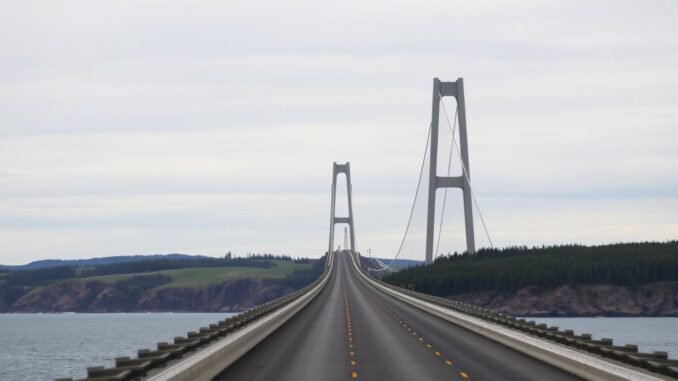
Spanning about 13 kilometres at the Abegweit Passage, the bridge is at its narrowest. Its curved path leads drivers to the open water and vast skies. The navigation span is about 60 metres high, allowing large ships to pass underneath.
This bridge is a key part of the Maritimes’ highway network, making travel easier all year. It replaced seasonal ferries, changing how goods are moved and families visit. It also helps businesses plan their deliveries better.
Coastal paths and protected areas surround both ends of the bridge. The Cape Jourimain Nature Centre offers views of the Northumberland Strait. Near Borden-Carleton, lookouts show the bridge’s S-curve. The bridge is a major tourist spot for both PEI and New Brunswick.
Together, the setting—sea, wind, and tidal flats—shapes the experience of this landmark every day of the year.
| Location Element | Details | Why It Matters |
|---|---|---|
| Waterway | Northumberland Strait, Abegweit Passage (~13 km wide) | Narrowest point enables efficient crossing and marine access |
| Endpoints | Borden-Carleton, PEI ↔ Cape Jourimain, New Brunswick | Creates a reliable interprovincial link on the east coast |
| Vertical Clearance | Approx. 60 m at the navigation span | Supports cruise ships and commercial traffic beneath the structure |
| Surroundings | Coastal marshes, dunes, and boardwalks near conservation areas | Scenic setting enhances its role as a tourist attraction |
| Regional Role | Continuous highway link across Atlantic Canada | Strengthens mobility for residents, visitors, and trade in the Maritimes |
Key Facts: Length, Route, And What It Connects
This bridge crosses the Northumberland Strait, linking PEI to mainland Canada. It’s a key route for both freight and travel. Many wonder how long is the Confederation Bridge. Knowing its length helps plan trips and understand the vast sea it spans.
Confederation Bridge length and design specifics
The Confederation Bridge is 12.9 km long. It’s a remarkable structure, built with a unique design. The deck is 11 m wide, with barriers to protect against strong winds.
It has 62 piers, with 44 main ones spaced 250 metres apart. A 60 m span allows big ships to pass. This design also helps it withstand harsh winter conditions.
Route 1 and Route 16: Trans-Canada Highway connection
The bridge is a vital part of the Trans-Canada Highway. It connects Route 1 on PEI with Route 16 in New Brunswick. This link saves time and ensures goods move smoothly, even in bad weather.
Borden-Carleton, PEI to Cape Jourimain, New Brunswick
The bridge links Borden-Carleton on PEI to Cape Jourimain on the mainland. It puts travelers on Route 1 towards Charlottetown and Summerside. It also connects to Route 16 for Port Elgin and more.
World’s longest bridge over ice-covered water
This bridge is the longest over ice-covered water. It faces challenges every winter. But, its design helps ice flow, keeping the route open for PEI, New Brunswick, and the Trans-Canada Highway in Canada.
History and Milestones from Idea to Opening
Ideas for a fixed link across the Northumberland Strait have been around for a long time in pei history. From early dreams of railways to modern engineering, it has changed travel, trade, and pei identity. It has connected Charlottetown to the mainland.
Early fixed link proposals and “Fixed Link” nickname
In the 1870s, Senator George Howlan suggested a railway tunnel under Abegweit Passage. Later, in the 1950s and 1960s, Ottawa looked at a rockfill causeway and mixed bridge–tunnel ideas. Mariners were concerned about tides and navigation, so the plans were put on hold.
The idea kept coming back, and Islanders started calling it the Fixed Link. It was a nickname for a year-round road connection. This would change how people got to Charlottetown and beyond.
The 1988 plebiscite and public debate
In 1987, Public Works Canada asked for proposals, and the debate grew. Premier Joe Ghiz set a vote for January 18, plebiscite 1988. Islanders were asked if they supported a fixed link.
A 59.4% “yes” vote was a big moment. It showed a split between tradition and growth. Supporters talked about steady jobs and reliable travel. Critics were worried about ferries, small businesses, and pei identity.
Construction timeline: 1993 start to May 31, 1997 opening
Strait Crossing Development Inc. won the bid after a federal review. Work started on November 1, 1993. Crews built massive precast pieces in 1995 and 1996.
Offshore placement moved forward with each season. At midnight on November 19–20, 1996, the last girder was placed. The bridge opened on May 31, 1997. It was a dream come true for pei history.
Gateway Village and post-opening developments
With the ferries gone from Borden-Carleton, the area became gateway village. It’s a place to stop, shop, and learn about the crossing. The site now has visitor services and small businesses.
It ties the bridge to local culture. Exhibits and wayfinding help visitors find their way to Charlottetown and coastal communities. It keeps the fixed link’s benefits alive in Island life.
Engineering Marvel: Structure, Materials, and Safety
The Confederation Bridge is a true marvel of engineering. It’s built to withstand the harsh Atlantic weather and ice. Its design makes driving smooth, balancing weight, wind, and waves perfectly. High-quality materials ensure safety without losing efficiency.
Multi-span post-tensioned concrete box girder structure
The bridge’s span uses a special method called balanced-cantilever. It’s made of a post-tensioned concrete box girder. This design fights off strong marine forces and keeps maintenance costs low. The durable concrete and steel last long, even in harsh salt spray and freeze–thaw cycles.
62 piers, 250 m main spans, 11 m deck width
The bridge sits on 62 piers, with 44 main units at 250 metres apart. It has a 11-metre deck for two lanes and barrier walls to reduce wind. The gentle curve helps drivers stay alert and shares loads evenly.
Ice shields and iceberg impact deflection cones
Each pier has an ice shield to split moving pack ice. At the waterline, there are cones to deflect icebergs. They turn impact into sliding force, protecting the bridge and keeping it safe during heavy ice runs.
Clearance: 60 m at navigation span, 40 m near shore
Vessels can pass under a 60-metre vertical clearance at the main span. Near shore, it’s about 40 metres. This setup supports marine traffic and keeps the bridge stable in storms and tides.
Crossing Experience: Speed Limits and How Long It Takes
The drive over the Confederation Bridge is smooth and quick. People often wonder how long it takes to cross the bridge. They also ask about the weather during the crossing.
Speed limit and weather-related adjustments
The speed limit is 80 km/h (50 mph). The speed can change in high winds, snow, or fog. The bridge has lights at night and barriers to fight crosswinds.
High-profile vehicles might go slower. There could be temporary rules in strong gusts. Drivers will see signs before they start.
How long does it take to cross the Confederation Bridge
Most vehicles cross in 10–12 minutes at 80 km/h. This time includes normal traffic and slight delays.
On clear days, it’s faster. But, winter weather or fog might add a few minutes. It’s best to plan for a quarter hour to stay relaxed.
Driving tips for the Northumberland Strait crossing
- Keep a steady 80 km/h and avoid sudden lane changes; these simple driving tips improve flow.
- Watch wind advisories and keep both hands on the wheel, even in vans, SUVs, and trucks.
- Do not stop on the bridge; pull into designated areas only after exiting.
- Use low beams in fog and increase following distance to maintain sightlines.
| Aspect | Typical Conditions | What Drivers Experience | Why It Matters |
|---|---|---|---|
| Speed limit | 80 km/h, reduced during wind, snow, or fog | Consistent pace with clear electronic advisories | Sets safe expectations for a smooth northumberland strait crossing |
| Crossing time | About 10–12 minutes at posted speed | Short, steady drive with limited interruptions | Helps plan PEI travel without tight timing |
| Wind management | Concrete barriers and operational alerts | Lower crosswind exposure but gusts may occur | Improves control, specially for high-profile vehicles |
| Visibility | Continuous lighting; fog may occur | Reliable night guidance; slower in dense fog | Supports safe pacing and predictable flow |
| Best driving tips | Steady speed, no stopping, longer following gaps | Reduced stress and safer lane discipline | Minimizes incidents and keeps traffic moving |
Tolls and Recent Confederation Bridge Toll Reduction
Travelers heading across the Northumberland Strait watch their time and money. The latest toll cut on the Confederation Bridge changes travel costs to Prince Edward Island. It also affects the Wood Islands–Caribou ferry. Here’s how payment works, what you pay now, and how it compares.

Confederation Bridge tolls collected westbound-only
Only when leaving Prince Edward Island do drivers pay Confederation Bridge tolls. They pay at the Borden-Carleton plaza. Entry to the Island is free. You can pay with cash, Interac, or major credit cards. The charges are tax-exempt, making travel costs predictable.
Current tolls: vehicles, motorcycles, pedestrians and cyclists by shuttle
As of August 1, 2025, two-axle automobiles and motorcycles pay $20. There’s no extra charge for additional axles. Pedestrians and cyclists must use a shuttle service westbound. Fares are $4.75 per pedestrian and $9.50 per cyclist. Extra baggage costs $4.25 per bag after the first.
Before the change, the bridge rate was $50.25 for two axles plus $8.50 per extra axle. Motorcycles paid more than today. In 2018, vehicles paid $47.00, extra axles $8.00, and motorcycles $18.75. Shuttle fares were $4.50 and $8.75 respectively.
2025 federal subsidy and rate changes
A federal subsidy in 2025 allowed the Confederation Bridge toll to drop to $20 for cars and motorcycles. The previous rates were frozen in 2022 due to the pandemic and Hurricane Fiona. Now, there’s simpler pricing and lower travel costs for frequent users.
Comparison with Wood Islands–Caribou ferry fares
The Wood Islands–Caribou ferry also cut its fares by half. A standard car now pays $43 when leaving PEI. There are proportional reductions for commercial vehicles, motorcycles, bicycles, and foot passengers. People usually pay only when departing the Island, helping families plan their travel costs.
| Option | Who Pays | How You Pay | Key 2025 Rate | Notes |
|---|---|---|---|---|
| Confederation Bridge | Westbound (leaving PEI) | Cash, Interac, credit; tax‑exempt | $20 cars and motorcycles | No extra axle charge; confederation bridge tolls simplified |
| Bridge Shuttle Service | Pedestrians, cyclists (westbound) | On-site purchase | $4.75 pedestrian; $9.50 cyclist | Baggage $4.25 per extra bag after the first |
| Wood Islands–Caribou Ferry | Westbound (leaving PEI) | Terminal payment | $43 per car incl. passengers | Halved fares; proportional cuts across categories |
| Historical Bridge Rates | Westbound | — | $50.25 car (pre‑2025) | $8.50 per extra axle; 2018: $47 car, $18.75 motorcycle |
For route planning, the Confederation Bridge toll reduction is a plus for quick trips. The ferry’s lower fares are great for scenic routes. Both options help travelers budget their travel costs with fewer surprises.
Who Owns the Confederation Bridge and How It’s Operated
The Confederation Bridge is owned by the federal government. But, Strait Crossing Bridge Limited runs its day-to-day operations. They are based in Borden-Carleton, Prince Edward Island.
Strait Crossing Bridge Limited (SCBL) operations
SCBL is in charge of many things. They handle patrols, tolls, traffic, and emergencies. They also check the weather and ice to keep the bridge safe.
They fix barriers, check lights, and sand the bridge in winter. This keeps the crossing reliable.
Public–private partnership and maintenance approach
The bridge was built through a partnership. The federal government oversaw it, while private companies financed and managed it. Strait Crossing Development Inc. raised the funds, and SCBL took care of the bridge.
Inspectors watch over the bridge to protect it from damage. They check the concrete, ice shields, and joints. This helps the bridge last longer.
The Constitution Amendment Proclamation, 1993 (Prince Edward Island), made it possible. It allowed for tolls and helped with funding and maintenance.
Traffic volumes and year-round service
About 4,000 vehicles use the bridge every day. There are more during summer and holidays. The bridge is open all year, even in bad weather.
They monitor the bridge closely and respond quickly to problems. This ensures safe and reliable travel between New Brunswick and Prince Edward Island.
Construction Story: Workforce, Methods, and Heavy Lift Operations
The project started in 1993 and finished in 1997. It combined careful construction with smart offshore work. A big team and advanced tools worked together to keep shipping lanes open. This effort boosted the economy of Prince Edward Island during busy times.
5,000+ workers and economic impact on PEI
Over 5,000 people worked on the project. They included labourers, tradespeople, engineers, surveyors, and managers. Their hard work increased demand for services and supplies, helping the local economy.
Training programs helped workers develop skills. These skills were valuable in Atlantic Canada even after the project ended.
Amherst Head and Bayfield staging yards
Two yards were used for the project. Amherst Head on Prince Edward Island handled the biggest pieces. These included pier bases, ice shields, and long spans.
Bayfield, New Brunswick, focused on pieces closer to shore. A truss launched these units almost two kilometres offshore. This helped keep the project moving, even in bad weather.
HLV Svanen heavy-lift catamaran and offshore placement
The Dutch-built HLV Svanen was used for heavy lifts at sea. Its design helped place massive components accurately. The vessel had worked on other big projects before this one.
It stood tall over the shoreline, guiding each piece into place. Its work was key to the project’s success.
Precast components and 100+ year lifespan design
Quality was a focus from the start. Every major part was precast for strength and consistency. Then, they were moved by crawler transports along special rails.
This method reduced delays caused by weather. It also ensured a better fit. The design aimed for a lifespan of over 100 years. The last girder was installed in November 1996, with finishing work done in spring 1997.
Names, Culture, and Community Connections
The bridge’s name is important in Island life. It connects to memories, language, and culture. When people hear it, they think of the sea, ferries, and family trips to Charlottetown.
They also think of PEI identity, shaped by history and daily life.

Official naming and alternatives like Epekwitk Crossing
A naming committee, led by former premier Alex Campbell, suggested abegweit crossing. It linked the bridge to the Abegweit Passage and the M/V Abegweit. On September 27, 1996, federal minister Diane Marleau confirmed “Confederation Bridge” as the official name.
In April 2022, the legislature endorsed epekwitk crossing, using the Mi’kmaq name for the Island. This step showed respect for language and PEI identity. It noted that Ottawa would need to approve any change.
The Span of Green Gables and Abegweit Crossing references
Nicknames continue to shape public talk. In 1998, Irish president Mary McAleese called it the span of green gables, a nod to L. M. Montgomery’s enduring story. Many refer to it as “The Link” or “Fixed Link,” while others use abegweit crossing.
These phrases show how a structure becomes folklore. They blend tourism, literature, and local culture into a shared map of place.
Charlottetown’s Confederation legacy and PEI identity
The official name honours the 1864 meetings in Charlottetown. It sits alongside familiar institutions: Confederation Centre of the Arts, Confederation Court Mall, and the Confederation Trail. Some residents feel the label is used often, yet many see it as central to PEI identity.
The bridge now stands at the meeting point of stories—epekwitk crossing, abegweit crossing, and the span of green gables. Each thread helps describe how Islanders talk about home, history, and culture.
Tourist Attraction: Best Views, Photo Spots, and Nearby Nature
People visit for the bridge and stay for the beautiful coast. This place is perfect for taking your time, going for short walks, and enjoying the tide. The views are amazing on both sides, with paths and dunes framing the bridge.
Cape Jourimain Nature Centre vantage points
On the New Brunswick side, the cape jourimain nature centre has boardwalks, a lighthouse, and lookout decks. These spots offer wide views of the spans. Trails lead through coastal meadow and spruce, perfect for photos at high and low tide.
Visitors can walk under the bridge for a unique view. It shows the bridge’s scale, rhythm, and curve, great for photos at sunrise.
Bayfield boardwalks, marshes, and shoreline perspectives
The bayfield boardwalks cross salt marsh and quiet shoreline. Here, egrets feed and channels reflect the piers. It’s calm, open, and perfect for photos that balance water, sky, and structure.
Soft mudflats and sea grass create leading lines. With a tripod, these spots handle changing light and wind easily.
PEI viewpoints near Borden-Carleton and along the coast
On Prince Edward Island, viewpoints near borden-carleton show the elevated span and the view towards Jourimain. Pullouts along the south shore frame the bridge over red sand and rolling surf.
Even a quick stop near Gateway Village can give the best views at golden hour. The deck glows, and the Strait turns glassy.
Tips for capturing the structure in different seasons
- Winter: drift ice patterns add texture and scale; use a polarizer to cut glare.
- Spring: fresh greens and calm mornings boost clarity at wide angles.
- Summer: bright skies and long days expand shooting windows for various photo spots.
- Autumn: warm tones, softer sun, and gentler seas flatter the concrete arc.
Pack layers, mind the wind, and watch the tides for clean foregrounds. Across seasons, side light reveals detail, while cloud cover softens contrast for crisp, true colour.
| Location | Access & Terrain | What You’ll See | Best Time | Lens & Tip |
|---|---|---|---|---|
| Cape Jourimain Nature Centre (NB) | Exit 51, flat trails and lookouts | Piers, navigation span, sweeping horizon | Sunrise, late afternoon | 24–70 mm; use railings as a stable rest |
| Bayfield Boardwalks (NB) | Shoreline path over marsh | Curved deck with tidal channels | Mid-tide, calm evenings | 35–85 mm; polarizer for reflections |
| Borden-Carleton Pullouts (PEI) | Roadside pullouts, firm ground | Elevated spans and channel clearance | Golden hour | 16–35 mm; include red sand foreground |
| South Shore Beaches (PEI) | Sand and packed shoreline | Long profile across the Strait | After storm fronts | 70–200 mm; compress curve and clouds |
Events, Safety, and Notable Questions Travellers Ask
Special events on the bridge are rare and well-managed. Strait Crossing Bridge Limited (SCBL) and public agencies work together to keep traffic moving all year. Safety measures like barriers and lights ensure a smooth journey.
Terry Fox Run Confederation Bridge event considerations
People often wonder about the terry fox run confederation bridge idea. When charity events are planned, officials check the route, timing, and lane use. They make sure it doesn’t block the Trans-Canada Highway.
Organizers also consider wind advisories, use escort vehicles, and communicate clearly. Any approved event must follow strict safety rules.
Staff watch the weather, visibility, and speed to keep everyone safe. This ensures drivers and participants stay protected.
Has anyone ever jumped off the Confederation Bridge and safety messaging
Some ask if anyone has jumped off the confederation bridge. The answer is clear: don’t try it. The bridge is high, and the Northumberland Strait is cold and fast.
There are barriers, wind screens, cameras, and trained teams to stop dangerous actions. Safety for drivers and workers is the top priority.
Seasonal weather, wind advisories, and travel planning
The weather can change quickly over the Strait. Ice, fog, and winter storms might lead to wind advisories or speed limits. It’s important to be prepared.
Plan your trip by checking alerts and forecasts before you go. Allow extra time and pack for changing weather. By staying informed, you can have a safe and smooth journey.
Conclusion
The Confederation Bridge is a remarkable Canadian achievement. It’s the longest bridge in Canada, spanning 12.9 kilometres over ice-covered water. It connects Borden-Carleton, Prince Edward Island, to Cape Jourimain, New Brunswick, making travel faster and safer.
Its construction was a journey of vision, debate, and determination. Over 5,000 workers built it from 1993 to 1997. They used new methods like precast concrete and offshore assembly, setting records in marine construction.
Today, the bridge is run by Strait Crossing Bridge Limited. It offers year-round service with modern safety measures. Recent federal support has also made tolls more affordable, making it a key part of the region’s economy.
The bridge has become a symbol of the region, with stunning views at both ends. It’s not just a road; it’s a vital link for trade, tourism, and daily life. It connects the east coast travel economy of Canada.
From its name to its iconic views, the Confederation Bridge has changed how we see the Island and mainland. It offers an efficient route, breathtaking views, and a modern landmark that celebrates its history while propelling the region forward.